


About this project
My name is Olav. I'm a sailor from Norway. I launched this site while on a sailing trip in 2021.
HarbourMaps is a crowdsourced harbour guide. This is a short story about how the project started, and the philosophy I follow when developing the site. I aim to make this the world's best harbour guide for sailors and boaters, and I hope you want to be part of expanding it to new geographies.
Is the page empty or lacking in the areas you know? Once someone starts to add pictures, it very quickly becomes populated and a valuable resource for the local community. Have a look at Norway and Sweden to see what a well documented geography looks like.
2021: The beginning
For many years I had missed a good online overview of harbours in Norway and the Swedish West Coast (my home waters). More specifically I wanted a map of anchorages. With a connection between the wind directions they offered protection against and the wind forecasts for the coming night. So that I could find the best possible anchorage for the coming night.
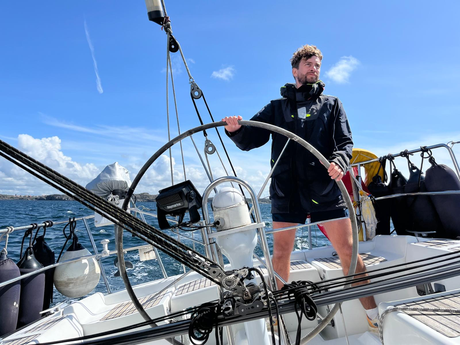
Photo: Olivia Rekman
It didn't seem too hard to build, and every spring I hoped that someone had launched the site. But they never did. In 2021 I sailed slowly along the Norwegian coast, from Halden to Brønnøysund. This was mid-covid, and time seemed to pass slowly. I make software for a living and I own & operate two sites that are used by the construction sector (Plankepriser.no and BuildPilot.com). I had my laptop with me and worked from the boat.
Halfway through the trip, I decided to launch this site myself. I cleared a week in my calendar, docked in Kristiansund Harbour and coded 12 hours a day. The site was launched 3 days later. It was far less sophisticated than the current site, but it worked. It had a map, and it allowed users to add harbours, upload photos and write reviews. Enough to get it going.
A few years earlier a Facebook group called "På Svai" (on anchor) had been created, where members shared the location of anchorages together with photos and descriptions. They had also started collecting the harbours in a shared instance of Google Maps. But this is not an ideal technology to capture and display the information. So we joined forces and members of the group started populating HarbourMaps with photos and reviews.
It turned out I was not the only one who wanted an online map of anchorages and marinas. The site started to grow quickly, as more and more people added harbours, pictures and reviews.
Later in the week I coded the feature that connects a harbour to good and bad wind directions. This was connected to the wind forecast from yr.no. Now it was possible to find the best harbour for the coming night. Later that summer I wrote a script that analyzes the topography around the harbour to automatically decide which wind directions it gives protection against.
2022: Expansion to Sweden, Denmark and beyond
For Norwegian sailors, the Swedish West Coast (Västkusten and Bohuslän) is a favourite destination. It only took a few weeks before Swedish harbours were added to the map. Then Danish harbours. And the next summer I expanded the site with marinas and anchorages across the globe.
As of june 2025, we have turned this site into the definitive guide of harbours in Norway and Bohuslän. No other site comes close to it in coverage and accuracy. We are also well on track to cover the rest of Sweden and Denmark. A bit behind are the geographies close to Scandinavia: The north coasts of Germany and Poland, The Netherlands and UK. Those areas have been documented by Norwegian and Swedish sailors who sail further away from home. And by local sailors that have found the site while sailing in Scandinavia, and then kept adding harbours closer to home.
I launched the site as a Norwegian project, and called it Norsk Havneguide (Norwegian Harbourguide). The url norskhavneguide.no is not meaningful outside Norway, and as part of the expansion I have mirrored the content on harbourmaps.com and svenskhamnguide.se
2023: Adding more features
This spring I had time for another long trip. Longer in time than distance. I spent all of June and most of July sailing in Bohuslän in Sweden. If this was a business I would code all the features during winter, so they could be launched before the sailing season. But it is very much a hobby project, that I work on when I feel motivated. That means I mostly develop the site while out sailing. With close to two months at sea, I had good time to code.
Adding facilities to the maps
One thing is to know that a harbour provides toilets, showers and a sauna. But where can you find them? I added a feature where users can add these facilities in the maps. They are also added to the screenshots of the maps, that are displayed together with the pictures of the harbours.
Collect AIS data to find the guest piers and anchorages
In July everyone goes sailing, and the harbours are crowded. Some bad weather was coming, and I wanted to find a harbour that still had room for me. I checked Marine Traffic, to see which harbours had fewer pleasure craft at that time. It's not a perfect measure, but gives at least an indication of how crowded the place is.
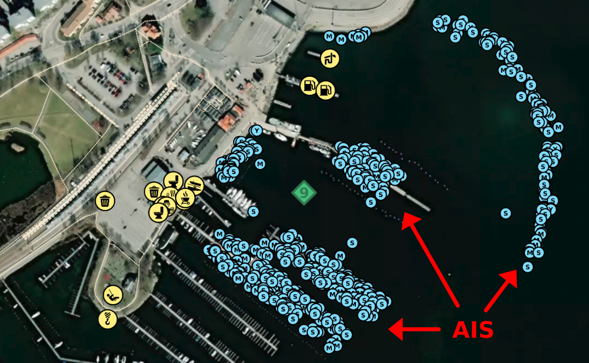
That night it dawned on me that every day new boats enter the marinas with their AIS. What if I collected a time series of AIS signals and was able to filter where boats had stayed the night while out on a journey? That would not tell me if the harbour was crowded right now, but would it be possible to figure out which piers that can be used by guests?
I got hold of some historical AIS data and started experimenting. Without revealing the secret sauce, I was able to detect where pleasure craft have stayed the night while on a journey. In this screenshot from Nynähamn in Sweden, we can see a lot of light blue dots. That is where pleasure craft have stayed the night while on a journey.
The algorithm works surprisingly well, and filters away the AIS signals that have been shared by boats that are in their home port. Now it is very easy for us to find which piers we can use as guests in Nynäshamn (and which piers we should avoid). The magic with this feature is that it works in almost any harbour in the world.
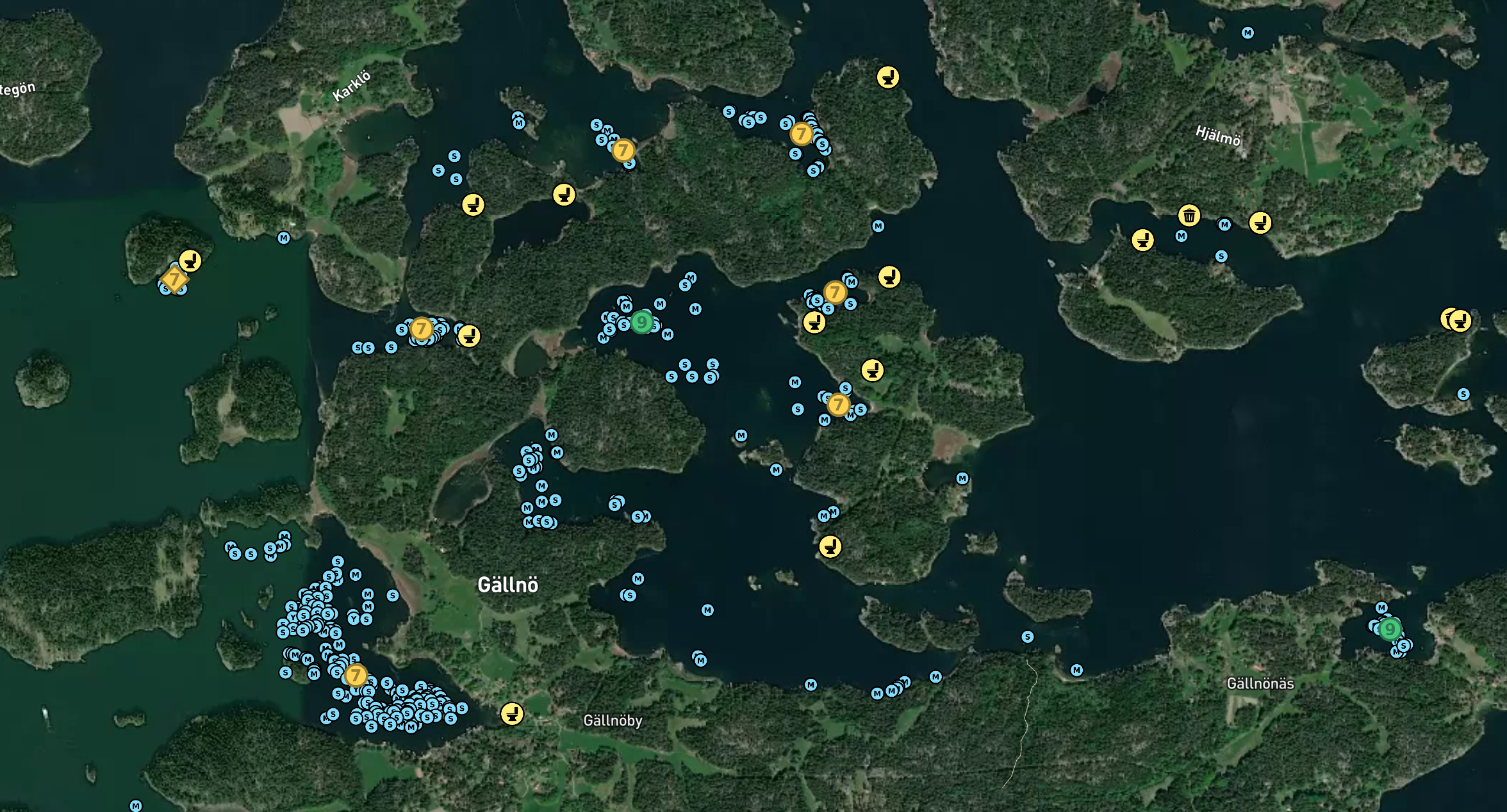
Below is a screenshot from anchorages around Gällnö in the Stockholm Archipelago. We can quickly see that some spots have a lot more blue dots, from more visitors having visited. Presumably because those anchorages are beautiful or offer better protection against wind and waves. When we zoom in, we can see exactly where others have anchored in the past. And where they have moored against the rocks.
You can read more about this feature here.
2024: Payment for non-contributors
I launched the site without thinking much about the financials. Initially it only cost me 5 dollars a month to keep it operational, but as the site grew in content and popularity the costs grew as well. I had to upgrade the server several times to handle the traffic, and each time the map is loaded, I have to pay a small fee to the company that provides the underlying map (mapbox.com).
In 2024 the direct costs of keeping the site operational were a few thousand dollars. I never planned to make money from this project, but I also never planned to pay that kind of money out of my own pocket so everyone else could have a free harbour guide.
I considered selling ads or finding sponsors. The traffic is not large enough to generate enough money from ads. Sponsors could have been a viable path, but I would rather not spend my time organizing it. This site is a fun hobby project, and it's important to me that the work is enjoyable. I also asked a few users what they thought, and they all preferred to pay rather than have the screen blocked with an advertisement.
I decided to place the map behind a premium membership. The premium membership is activated by payment or by becoming a contributor. This seems to be a fair balance. Users who only want to access information can pay, contributors get free access, and I cover the costs. There is also a little profit left, which I think is good. That makes sure I stay motivated to develop it further and keep the site operational for the future.
Except for the maps, all the content is freely available to anyone. All photos, reviews and information about the harbours can be accessed freely. Unless there are dramatic changes in user behaviour in the future, the system will stay open and free like that.
2025: Adding icons to photos
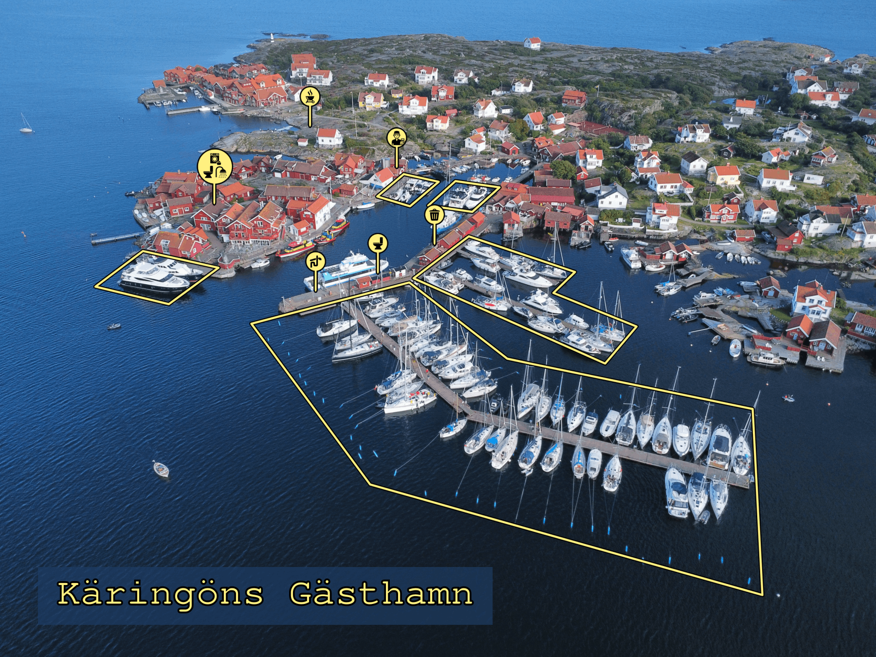
The feature where users can add icons to the maps became very popular. Right now there are 16805 icons added to the maps (try adding an icon, and see this number increase). To make this even more helpful I have long wanted a feature where you can add the same icons to images. This makes them extremely useful in planning the approach and getting around in the harbour.
It is not trivial to create a "drawing program" that makes this possible, and I have put it off for a long time. But AI has gotten extremely good at coding features like this, so with the help of ChatGPT, I was able to complete the feature in a day. You find a link to the editor below the images on the harbour sites.
Here is what it looks like on Käringön:
Join us in making this the world's best harbour guide
I hope you have enjoyed reading the story about how this page was developed. And maybe you want to help us expand it further?
It is really easy to upload pictures, reviews and add icons to the maps. It only takes a few photos to make a new geography look good. The experience from Norway and Scandinavia is that more people will help you add even more photos and information as soon as you get it going.
For each update you make to the page, you get contribution points and rise through four officer-ranks. It's easy to get to the first rank, and somewhat more prestigious to make it to the all time top-50 list.
Please reach out if you have any questions. When you make a user you will get some intro e-mail from me. They are sent from my personal e-mail account, so you can just reply to them to get in contact with me.
Fair winds,
Olav Pekeberg
Oslo, Norway
June 2025